


moulinet sud

vertygo
User
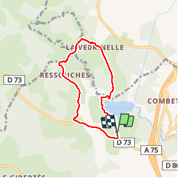

Length
6 km

Max alt
1126 m

Uphill gradient
103 m
Km-Effort
7.4 km

Min alt
1074 m

Downhill gradient
99 m
Boucle
Yes
Creation date :
2019-05-30 12:52:21.428
Updated on :
2019-05-30 15:11:36.136
1h55
Difficulty : Very easy

FREE GPS app for hiking
 SityTrail
IGN / Geographical institutes
SityTrail Plus
The world is yours!
About
Trail Walking of 6 km to be discovered at Occitania, Lozère, Le Buisson. This trail is proposed by vertygo.
Positioning
Country:
France
Region :
Occitania
Department/Province :
Lozère
Municipality :
Le Buisson
Location:
Unknown
Start:(Dec)
Start:(UTM)
518430 ; 4942705 (31T) N.
Comments